Saturday 31 March 2012

Paddling out

When surfers head out to catch the big waves, whenever possible they would paddle out in deeper water, like an estuary, where the waves are not breaking, otherwise the journey out would require battling through the breakers resulting in much lost time and energy before catching the big wave home (if they even manage to paddle out that is).
Thats the way I designed todays ride, the "big wave" being the ascent of Belchen, or at least as far as a road bike would go. So I stayed on the French side of the Rhine for the first 50km, the idea being to "paddle out" down the river then swing in to the east and ride the big Schwarzwald mountains from the north back home.
This section really is a time triallers dream (ie flat and boring), so little traffic it was easy to cruise along and be disappointed when my computer said 32km was below my average speed.
I was aiming to the Rhine at a place called Fessenheim. Tell tale signs alerted me before I arrived at this place, seldom used rail lines, large amounts of barbed wire and many security cameras around the perimeter that this was not a normal hydro electric power station. Only when I got to the main gates did I realise that yes, this is a nuclear power plant, and the oldest operating one in France - really not far from Basel and many other populated areas so not surprising to discover later about the many campaigns for this place to close down.
Hazy days, and it wasn't before I was 10km from Staufen that the Blackforest mountains appeared before me, rising up from the flat plains around the Rhine. Busy roads at first, but somewhere the traffic dissolved away, and I was left with the outstanding ascent of Wiedener Eck, and further up to the cable car below Belchen, @1160m. I had been hoping to climb further, but it looked like the road from the car park to the top was for mtb or 4 wheel drive only.
The big wave of Belchen carried me onwards towards Todtnau, but turning left through Prag and on to the next wave in the set cresting at 1050m. Its here that riding waves of mountains as opposed to waves in the ocean has the benefit that I can stop and have a huge slice of Blackforest gateau and large coffee (at Hochkopf) before moving on. After this, I had no need for the energy gels kept in my saddle bag for emergency use.
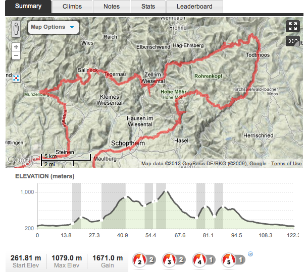
3 smaller waves continued in the set, the climb out of Zell being the most significant and soon I was fast approaching the Rhine to the south and with it the Swiss border. Here I was fortunate to be overtaken by a speedy pair, and as I had been debating with myself whether to ride home on the Swiss or German side of the river, sticking on their wheel was clearly the best option and so helped the average speed for the day to a respectable 26.4kph for the 172km ride. Strava says 3042m gain, mapmyride says 1968m but as I have joined the Strava Classic Climbing challenge I am happy they are giving away as many meters of ascent as they do.

Sunday 25 March 2012

Blackforest Double

No more back aches, shoe position just about sorted (right foot still needs few mm adjustment) and fine weather made for a great biking weekend discovering new routes in the Blackforest. Almost came to an end on the fast road section to Steinen yesterday though, when an elderly gent overtook a van, I could see what he was doing but couldn't believe he wasn't going to prevent his overtaking action when he saw me, instead I had to escape onto the grass verge then aimlessly shout and make hand gestures in the middle of the road after the event.
After surviving that, I was on a mission to discover new roads, like the days of rindo hunting in Tokyo-to. The map I use is full of bike routes in the Schwarzwald, and so colourful that its hard to see the real roads underneath the coloured trails. This often means the road disintegrates when you are someway up the hill to dirt and stone, great for mountain biking but not so good for cosmic wheels. This happened several times north of Steinen, before I took the usual route up to Neuenweg and attempted to follow the map route to the top of Belchen, the 3rd highest mountain in the Blackforest. Again, the route was but a bridleway and would be great for the Stumpjumper, but I will have to attack Belchen another day from the north.

Instead I enjoyed a great climb up and down to Badenweiler, then took a new route up to Blauen, with the intention of enjoying the first black forest gateau of the year. Instead, at the top I found a closed down hotel and visitors center, and what looked to be the site of a great downhill mtb trail.

That was Saturday, and over the past few weeks I've been aiming to do ~130km hilly rides Sat and Sunday, the aim being decent rides on sequential days. Really hope we have weather like this over easter, as a 4 day training session would be ideal at this time of the year.
Todays ride took me over a new Rhine crossing at Augst, and this route might well find its way into the "umleitung" = my daily commute as its fast out with no traffic lights crossroads etc at the start.
So over to Gersbach, descend then Todtmoos, back over to Zell then more up and down to Endenberg, Shlecktenhaus and back to Steinen and home.
At the coldest part of the ride, up above Todtmoos, I was admiring the snow piled up by the side of the road then fastening my jacket for the descent when I rode straight over a sizeable rock - it felt sharp, and I stopped to check for a puncture before I could here the hiss and later a trademark snakebite was to be found on the inner tube. So I got to try out CO2 cartridges for the first time. Obviously I made a mess of the first one, only half inflating the tyre. An aborted attempt on the half inflated tyre meant I had to use the second cartridge, which did the job, but now of course I was left with no way to repair another flat if it should happen. Is it worth the risk of cartridge v carrying a pump?
At least I had a decent seat for my mechanic interlude, watched over by St Antonius, but it was feeling cold sitting around at 1040m. Felt so warm once I was back in the valley.

Overall, today's route could be a classic route, doesn't need much tweaking at all.


Monday 19 March 2012

Spring has Sprung

With the warm weather and the first weekend to leave the winter leggings behind, I wanted to do the same tough training ride as last year which got me through etape and other sportives and by doing so have a yardstick to measure my season opener and progress through this year.
It was a little over 5.5hrs, similar to last June, but from what I can guess the time for this circuit was down to 5hr 2min in July after l'etape and before granfondo. So a good opener, and the goal is to do this loop in under 5 hours before August.
...BUT I've never finished a ride on the "summer" bike in such pain! I must have spent too long on my winter bike, which of course does not have the same geometry. For this reason, my back was aching towards the end, nothing lasting after the ride but not the usual finish to a 125km ride (OK, this was a massive amount of climbing)
The back ache will go, but first the more worrying issue is my new carbon shoes and carbon pedals. Why spend so much on these items when at the end of the day Ive been used to my friendly spd shoes which have moulded to my feet after many years, only to give me knee ache? Well, the shimano shoes are now my commuting/mtb shoes, so I needed a fresh start. Bontrager RXL, Keo Max carbon pedals sounds nice but now I'm left with adjusting cleat position tiny millimeters to prevent more knee pains.
Must get this sorted out soon!

Sunday 4 March 2012

Mapymyride v Strava round 2

Looks consistant - distance, speed, max speed all perfect. But this was not 1024m ascent! Disappointed that Strava missed my time for Dornach - Gempen as well, I really put in a decent time here. For some reason it only recognised a segment in the middle of the climb. On the early slopes an average gent was quickly brushed aside, but just ahead was a young guy with "gold wurst power" on his kit. For the first half, he had the edge and was powering ahead, gradually getting further away from me. But I kept my pace well, and the young chap was reeled in after 16mins or so, and I thought he was going to keep my wheel but he faded quickly. Would have been around 19 mins, not far off king of the mountain but it would have brought me up the leader board.
So heres the results, distance and time by Strava, correct hill measurements by mapmyride.


After that, I exported the data from mapmyride and uploaded to ridewithgps - one of the nicest layouts for post ride analysis. Here, the final total for my ascent is 1329m! So clearly mapmyride has a sensible algorithm for rounding gps data. 

Saturday 3 March 2012

Mapmyride v Strava

On todays ride I tracked my route with mapmyride and Strava, I was interested to see how the two android apps compared.  Nice that Strava app has been updated with my main gripe now fixed, ie you can start recording a ride before you have a GPS signal. This means you dont have to leave the house, get away from tall buildings then take the phone out and press the start button. Strava does a better job than me at time and distance, as I cycled a few minutes before I realised the reason my computer was not working was because my front wheel was on back to front!
Total distance Strava, 125km, my computer 125.17km.
Rolling time Strava, 4.38, my computer 4.33.
Maximum speed Strava 69.3, my computer 69.7.
The big difference is in total ascent, Strava claiming almost 800m extra! It really doesn't smooth well, if you look at the altitude of the climbs, its clear the mapmyride estimate is much better.
So the Strava app is very reliable for distance and speed, and at present mapmyride does not record these details, however I feel the total ascent is best represented by mapmyride.
I like the achievements section for Strava, with the King of the hill and personal bests for all sections. I guess its difficult to identify the real start and finish for very long climbs, Strava tends to chop them up into many sections. Going to have to take it out on Dornach - Gempen tomorrow morning I reckon....