Sunday 18 December 2011

Snow arrives

After an almighty final battle between the cold air and warm air on Friday across Europe, the cold air won on points and now it seems any precipitation will fall as snow for the next few months. The storm blew down many large trees all over the forest, obstructing the paths and bridleways in may places.
The restaurant at Gempen turm had taken a beating, many of its large roof tiles had slid off and the restaurant itself looked closed amidst the several cm of snow.
Once up high, I stayed in the whiteout for as long as possible, exploring new lanes south and getting completely lost. The snow was light and dry, no ice, so it was possible to ride at speed - though eventually my front derailleur had so much snow and ice it wouldn't shift down to the small ring.
Really felt strange descending back to the snow free St Jakobs park after being in the snow for several hours, just like being skiing all day then getting the train back to Tokyo in the evening. Not that getting back to Basel feels like getting back to Tokyo, thats a different matter.

Thursday 15 December 2011

Monday 12 December 2011

Scheltenpass

Still warm for this time of year, you can see the tiny patches of snow near the Scheltenpass (1050m) in this photo.

Expected to be cold and tired by the time I got to Liestal, instead it was warm enough to climb up through the clouds to Gempen.

http://www.mapmyride.com/routes/view/60590154

Friday 25 November 2011

Haute Route 19-25th August 2012

I'm in!

http://www.hauteroute.org/raceinfo/downloads

Big-mountain riding's for macho assholes with a death wish.
No, it's not. lt's the ultimate rush.
There's nothing that comes close to it.
Not even sex.
Maybe that's cos you're not doing it right, Roach.
Just cycling out in a big mountain pass is total commitment.
You can't just call time-out if you don't like the way things are going.
So, what's biggest? Alpe d'huez?
- Ridden?
- Yeah.
Galibier.
Stelvio.
Norikura, Japan.
Cime de la Bonette.
No way la Bonette is bigger than Norikura, bro.
It will be next year.
Bodhi believes the Haute-Route is coming next year.
Haute-Route. What's that?
That's kind of a legend.
No, it's real. lt's absolutely real.
Everything moves in cycles,...
...so twice a century the mountains let us know just how small we really are.
The route comes out of the plains of Geneva, tearing south towards the Med...
...it goes on and on for miles.
And when it hits the Alps it'll turn into the biggest cycle sportive this planet has ever seen.
And I will be there.
So will I.
(all whoop and yell)
If you want the ultimate, you gotta be willing to pay the ultimate price.
It's not tragic to die doing what you love.
It's how I want to go.
I ain't gonna live to see 40!


---In case this is too cryptic, you need to have seen Point Break to recogise the modified dialog

(http://www.youtube.com/watch?v=Vv6kQrhhTPw after 10mins)

Sunday 13 November 2011

Internationales Radquer Frankendorf

Todays mtb mission was far more technical, and I paid for it in the end. An international cyclocross event was being held in Frenkendorf,  a small town nestled in the hills south of Prateln. The route to get there meant a deviation from the long climb to Gempen and heading east along some new and tasty singletrack, past an old ruined tower then descending through leaves to the town itself. It was easy enough to find the site of the event, however I was there well over an hour before the main event and so had to stand around, watch the juniors event then climb back partway up the hill to keep warm.
In practise, and in the junior event most riders were hopping over the barrier you see in the video below. But in the race, they were going too fast to hop, land and hop again so all were dismounting. This caused a small pileup on the first lap as there was a faller, but the second time round they were a little more spread out.
Impressive skills, but most impressive was their use of Easton and Lightweight wheels, I thought cyclocross riders used sturdier wheels, but this shows the strength of the deep rim wheels I suppose. I wouldn't want to ride this course on my cosmic carbones though.

It was a lovely ride home, climbing back up to the ruined tower then around to the usual tracks on a new route. But back on the familiar paths, I took a heavy tumble passing a horse and rider. I had slowed down, the rider  knew where I was and I cycled through the mass of leaves to the left of the firetrack. But the leaves were hiding a banked ditch, and the wet leaves which looked oh so nice last week were my downfall today as they slipped and took my front wheel right beneath me. There was a fair amount of blood from my knee down to socks, elbows grazed and heavily bruised wrist but I got home safely. The cute rider looked very concerned, as I was trapped in the wrecktangled bike for a while, and my knee didn't look good, I should have played for more sympathy before heading off down the hill.

Maybe I should stick to national bike route #3...


Saturday 12 November 2011

National MTB Route 3


Today I had no new ideas for new routes and so opted to try the National mountain bike route number 3, or the Jura bike route, which starts in Basel and eventually finishes in Nyon, on the banks of Lac Leman/Lake Geneva, not so far from Geneva itself. Its 357km in total so today I could only manage the first 60km as far as Delemont.
As expected, most of the route was firetrack and significant tarmac sections so technical skills were not needed today. In fact, a cyclocross bike would have been preferable today to cover the distance at a faster pace.
The start is definitely a great route out of Basel that I've not seen before. Between the parallel inhabited conurbations stretching south to Dornach in the east and Therwil in the west is a hilly area which gives great views towards Gempen, it really looks like a significant hill from here, I've always seen it close up from the road in the past so this route gave a new perspective on the land south of Basel.
On the road/track out of Laufen, I noticed a very obvious 2m diameter ball on a post, with the word "Sonne" below it and a lot of text which I didn't stop to read. Was this a sunlight recording device? Not so far up the track a smaller sphere with "Merkur", could this be a thermometer? I passed a few more objects which I didn't read, it was obviously some art in the countryside project. Not until I was a LONG way up the hill did I see a larger sphere named Jupiter. Only now did I realise this was a model of the solar system, set along this track in proportion to the distances between the planets! After that I didn't notice the other planets, thought Saturn would have been obvious but no.
There was one section beyond Grindel which was unrideable, but only about 1km, then its a nice plateau before a drop to Montsevelier. From Montsevelier to Delemont, the path could almost be called singletrack in places, here it is beyond the capabilities of a road bike so the final section made it feel like it was worth taking the mtb out today.

Saturday 5 November 2011

der Herbst

Although this is my first mountain bike blog entry, the stumpy has been out on the hills south west of Basel up to Gempen several times now, and I'm getting to know how to join the best singletrack sections together. Some of the best parts are now out of use as a group is about to prepare them for a manicured downhill bike trail, no signs of any tailbuilding so far just very obvious signs saying no mountain biking which even I can understand.

The best of the autumn views were last week, it really was absolutely stunning looking out from above the limestone cliffs close to Gempen turm.  Alas I didn't take my camera with me so today I could mostly take shots of the blanket of fallen leaves.

Also of note, as its my first winter here I don't know if we had a cold spell 3-4 weeks ago, or if now is unseasonably warm. So still out in shorts and fingerless gloves, but I would expect to have some nice snowy photos looking across Basel-Land very soon.

Saturday 22 October 2011

Return to the Vosges

I felt like I had unfinished business in the Vosges mountains after my first visit last week, the roads leading up to the route des cretes meeting at Markstein looking interesting, I had to squeeze in one more visit before the winter.
Today I took the direct route from Basel to Altkirch to Thann, an obvious route and very little traffic, but still the road was too long and straight to be interesting, it felt more like a highway in places despite the lack of traffic. Not a bad route though, and the distance would be covered very quickly by a small grupetto.
There was one small climb which popped up on the mapmyride profile, it was lined with trees planted by Napolean III, not far from Altkirch.
Once I was in Thann, it feels like you're back in some magical wine kingdom, which in fact you are. All the villages here are so well kept its a joy to cycle through them. Definitely must do the Colmar to Strasbourg section when its warm again next year.
Today the main climb started from the almost completely dry lake beyond Kruth. Theres a very generous 14km climb up 600m to Markstein from here. No downhill or flat, but it really is nice to climb upwards at speed and so I really liked this ascent. Towards the top there was heavy frost across the road and my rear wheel was slipping. As I climbed higher, I could see snow on the Grand Ballon, and soon enough I was in areas with small amounts of snow sitting in shaded areas by the roadside. Much colder than last week, but the autumn colours of the forest were more intense so it was for sure a good day to be on the hill.
Theres still more climbing beyond Markstein, and there I joined up with a local mountainbiker. Hes retired, and cycled over 14000km this year! Too cold for the road bike today for him. We made a pact to meet up at the Trois Ballons next year, an event he has cycled 10 times before. The finish of this event is La Planche des Belles Filles, a 12% climb at the end of a ride over 200km. As the Tour de France will be finishing at the same resort in 2012, it will be nice to get to know the climb before the masses of Germans, Dutch and English, let alone the French, paint the road all colours and names next summer.
The descent to Munster is much steeper and faster today, though I need to take it easy at the top in case theres anymore ice on the road. Florian at work told me about the famous smelly Munster cheese, so I make an effort to locate a fromagerie (not difficult at all). It really is quite strong, but there are worse smelling cheeses than this one. Wish the town would do something about its massive cobblestoned roads, they really are painful.
Also made a stop in Turkheim wine cave, my first visit to a cave. Its busy, several languages being spoken all sampling the wine from a very long tasting bar. Outside, cars are filling up with crates of fine wine. Would be very nice, but I dont have any suitable pockets to carry a wine bottle, but I'll be back for sure. Turkheim really is on the outskirts of Colmar, so depending on train times it would be worth finishing a ride here and having a meal with wine before a few km down the the station.
But then theres plenty more options in Colmar for enjoying the food and wine and architecture of Alsace.

 Route on mapmyride

Sunday 16 October 2011

Le Grand Ballon, Route des Crêtes

After a decent mountain bike ride yesterday discovering new tracks below Gempen and sliding down one uber steep valley resulting in slight road rash (shouldn't that be mud rash?) I was feeling a little bruised and tired today but still determined to venture into the Vosges mountains for the first time.
I wanted to ride out from Basel to test the roads and get a feel for the distance, it turned out to be fast and very little traffic all the way to Mulhouse. Would be easy to hop on a train next time to save 40km or so, or head out to Altkirch and avoid Mulhouse altogether - theres not much to see here.
Today was the first day in leggings and long gloves, chilly start but by the time I was Wittelsheim the low cloud evaporated and blue skies remained for the rest of the day. Still, it would be chilly on the higher ground.
At the top of the first col at 906m is Hartmannsweilerkopf, on which is a cemetery and national monument for those killed in the first world war. Worth a brief stop.
After this point the road is known as the "Route des Crêtes" - the route of peaks. Well theres one main peak, Le Grand Ballon at 1325m after which I followed the the route for an amazing 22km undulating at around 1200m before dropping down to Munster and the road down to Colmar. Its quite rare to find a road which continues at altitude after a major climb, so this route is a real gem.  The climb up to Le Grand Ballon really seemed to go on forever and on the lower parts I came across the familiar cobblestones as first encountered on the slopes of La Tremola, Gotthard pass. Thankfully it was only 3 very short sections, I was worried I would have another 8-9km of these cobbles all the way to the top! What was really cool is there really is a Grand Ballon at the top of the mountain, but you'd have to hike up from the road to get to it. Another day perhaps. Also its nice the French like to mark all their climbs every kilometer. Here the climbs were not marked with a gradient like in the Alps, but at least they marked how far from the top and the altitude every km, its always nice to know how much further there is to go.
The first ski slope of the day was at the top of the Grand Ballon, then at Markstein, and a few smaller slopes before the end of my ridge ride at Col de la Schlecht.
It really was a nice ride in the cool air, the forests all coloured for autumn it all reminded me of the ride I did last autumn in Nagano, along the Venus line from Chino to Bessho onsen.
Its a great route, and once you're off the main ridge you can soon be down amongst the vineyards of Alsace. The harvest was a couple of weeks ago now, but the leaves still remain on the vines so it all still looks very attractive. The whole "route du vin" from Mulhouse to Strasbourg is dotted with picturesque villages, wine caves and acre after acre of vineyard as far as the eye can see. I made a brief stop in Turkheim to take some photos, and of course the center of Colmar which is a must visit if you're in the area.
When planning this route I had though I might continue on beyond Colmar and see a few more of the villages on the way to Selestat, but all thoughts of this evaporated on the slopes up to the first col when I realised how far and really how big these climbs are. 150km for the day and I feel really tired now after another weekend on the roads and trails around Basel.
I'll definitely be heading back to the Vosges again, seem to be a thousand different routes here and with all the routes du vin villages to finish a ride, it could make for the perfect day.

Route on Mapmyride

Saturday 1 October 2011

Biasca - Luzern

Did I say Summer had ended? Not quite yet, its been a great week weatherwise and today was an excellent forecast for 1st October. So another opportunity to head to the big mountain passes!

This was an optimistic ride, 2 high passes then a loop of Lake Luzern. Again I took the early 6:03 train and this time got off 2 stops after Airolo, down the valley in Biasca. Early thoughts of getting off in Airolo then descending to Biasca would have been a waste of time, better to start as soon as possible with the long ascent of Lukmanier pass, or Lucomagna as all the signs are in Italian here. Even the train announcements switch solely to Italian in Ticino, no German translation here.
It was chilly starting off, but as its uphill for 42km from the station, I soon warmed up. Lots of vineries here, up houses, covering garden areas and even covering private car parking areas.
The whole climb was outstanding, lower down was incredibly green and I pass through several picturesque villages all with Italian architecture. As to be expected, the churches are highly decorated in these parts.

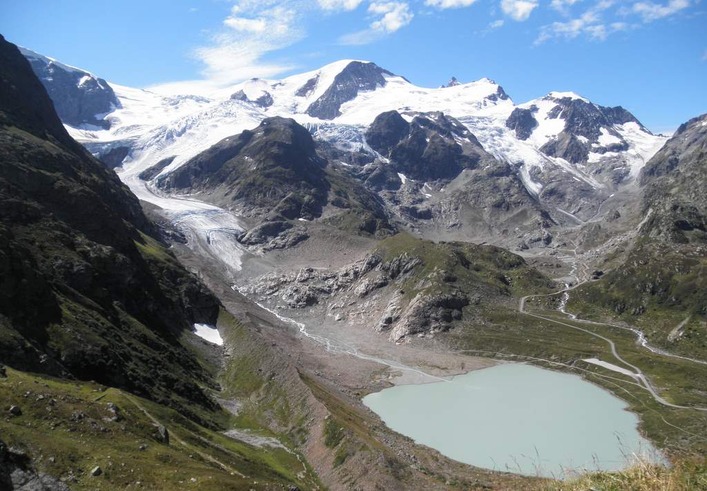
The mountains grew steeper around me, but this climb stayed a very friendly gradient and several km before the summit relaxed down to around 3-4% I guess so it was easy to speed through the scenery and really enjoy it. This was the first pass to have a non-obvious summit. Theres a parking area, restaurant and sign before the lake, but the road still rises to a summit within a tunnel by the lake, so not a place to stop for photos. The descent was outstanding, as gentle a gradient as the way up so no need to use the brakes much all the way to Disentis. Really enjoyed this pass, scenic, very little traffic, gentle gradient both sides.

Biggest cheesy fondue so far
In Disentis I turn right towards Andermat over the Oberalp pass. The Glacier express train is just leaving when I pass through, it twists away to the right then we meet again further up the road. At the ski station of Sedrun, I catch up with the train again, it is moving a glacial pace. It is waiting for a train to pass in the opposite direction, so must have been waiting in Sedrun several minutes. Must be the best way to get to these ski stations, travelling from Zermatt to St Moritz stopping at ski stations along the way sounds like a great idea to me.

Again, this pass is outstandingly beautiful. Theres an incredibly scenic golf course below Tcshamat, and near here is a small lake which is the source of the river Rhine. But its a short walk from the road, I'm not interested in seeing this this time. Might return to the source another day.

The road becomes the usual series of hairpin loops towards the top, but up to this point again the gradient has been forgiving. A more significant summit here, then its another fantastic descent down to Andermat, then the heavy traffic section down to Wassen.

Old and new Devils bridg
But today theres far less traffic than the day of AlpenBrevet, so I can freewheel down at ease. This time I make a stop at the Teufelsbrücke, the Devils Bridge, apparently built by the devil himself. Must have taken timeout from chasing the tour de France, so thanks to him for creating this wonderful cycle route.

The descent takes me to the start of Sustenpass, today I have no intention of turning left here and continue down, and down and down to Altdorf and then Fluela by Lake Luzern.
It would take a couple of energy gels to power me round what I originally thought would be 40km became just over 50 for the next leg of the journey to Luzern. Of course its mostly flat, but there are sections where the road climbs up 200m or so above the lake for a spectaular view. Cycle track all the way to Brunnen (apart from the narrow pavement sections that is) so nice to be out of the traffic here. Beyond Brunnen you can enjoy quiet(ish) roads again, really close to the blue water and enjoy the lakeside views all the way to Luzern.

There are many impressive places along the lake here, several marinas, several places to catch the ferries or boats across the lake and I imagine incredibly expensive houses and hotels. The water looked so amazing, I saw several swimmers, but I didnt have time to stop here and managed to get the help of one local rider up to Kussnacht, my sole riding partner for the day.

In the end, quite a monster ride of 188km at 24.4km/h with the 2 high passes and fantastic lakeside ride. I've now cycled over the 5 passes in the platinum category of AlpenBrevet, over 4 rides, and I'm more convinced than before that this is beyond my capabilities to ride the 5 passes in a day!
Another scenic ride from start to finish, I can't believe this is my Saturday ride, I really am lucky to live here and be able to cycle in scenery like this so easily.

Route on Mapmyride

Sunday 11 September 2011

Nufena, Grimsel, Grosse Scheidegg

Today I managed to "bag" two more high mountain passes which I had not managed to do so far due to bad weather. The weather forecast was great, and I had to make the most of the warm weather as for sure it will soon turn to autumn and the high passes will just be too cold even before the winter snow settles for good.
So I boarded the 6:03 am train from Basel to Airolo. Thats the earliest possible with a bike, as 5:03 ICN does not allow bikes.
As soon as the train arrived, I set off up the road to Nufenen Pass. Or as the start is in the Italian speaking canton of Ticino, Passo della Novena. Certainly warmer than the last time I was in Airolo, no cold feet or hands at any part of the climb today. The sign just beyond the station in Airolo says the pass is 23km away, and there is very little flat or downhill, just a long gradual ascent. It was slightly cloudy on the mountain tops, but otherwise nice alpine scenery to the top. At the top, the clouds cleared and the northern descent was in sunshine - which seemed to bring out the motorbikes in their thousands.
To be honest they're not such a problem, they don't take up a much space on the road as cars and campervans so overtake with a lot of clearance, its just the noise of the motors which you have to get used to. Must be great fun going uphill at that speed!
The only way is up  (Grimsel)
The descent all the way down to Ulrichen then Obergoms means the climb up to Grimsel starts from way, way down the mountain than Gletsch, where I turned left for the Silver route in the TransAlp. Its definitely a huge step up to Gold, but it has to be tried next year if its the same route. (Possibly not, this years AlpenBrevet was too popular and things must change next year)
The southern face of Grimsel Pass was covered with motorbikes racing in all directions, nothing special except for a Sunday with excellent weather, so avoid it if you don't like riding with bikers racing past. But the road is generously wide, so no close calls up here.
The descent down the north side of Grimsel was fantastic, its not so steep so I wasn't on the brakes much. Some unnerving sections of road again, the road surface causes my mavic rims to resonate and create a very loud buzzing noise. At first, it feels like a puncture, but now I ride on even though its loud and uncomfortable.
So beyond Innertkirchen, up the "sting in the tail" of the AlpenBrevet, and turn left for the Grosse Scheidegg. This is a small road, closed to traffic beyond the mid section and so it was very nice to leave the motorbikes behind here. But theres a price to pay - its extremely steep in places, starts at 700m and rises to 1962m with an average gradient of 7.7%. Thats quite high, but when there are 2-3 flat km in the middle section, it shows why this climb is a Hors Categorie climb in the Tour de Suisse.
Again, the only way, and best way to avoid the pain is just to look around and see the massive scenery, glaciers so close you could touch them and finish with some rosti and a Feldschlossen at the restaurant at the top.
Traffic free and amazing scenery -
but so steep (Grosse Sheidegg)
Was certainly a well earned break here, and I looked forward to racing down to Grindelwald, and on to Interlaken to catch the train back. Except for another loud noise, this time seeming to come from rubbing on the tyres. I checked the brake blocks, one of them was worth adjusting and so carried on. But the noise returned. The freewheel was not freewheeling well enough, and the chain was sticking and so rubbing against the tyre. I cleaned the sprockets, and still the problem occurred, so I found as long as I pedalled forwards I could get down the mountain - and there was still a long way to go. Tomorrow I'll get some degreaser and give it a good clean as a first step, but this could be an infamous slippage of the 11 speed campag sprocket, just beginning to show itself.
Beyond Grindelwald the road still dives down the valley all the way to Interlaken, but here the weather suddenly changed and I got a good soaking. Not a great end to a tough day in the hills, mechanical problems and a soaking, but I still back to the train safely and in good time so it was another successful mission in the Alps.

The route on mapmyride

This is how to descend the Grosse Scheidegg without a locking freewheel, stage 3 Brig-Grindelwald Tour de Suisse 2011, Peter Sagan descending fearlessly with great skill to catch Damiano Cunego and win the stage.


Sunday 28 August 2011

Cheesy Fondo

aka  - the Gruyère Cycling Tour was a very different day in the hills compared to the AlpenBrevet of a few weeks ago. The distance of 125km (also 85km version is available) and the 3 cols of low gradient, minimal ascent (do I really think 1640m is a small mountain these days?) looked to be a fast but challenging course on html.
So it proved to be - the first 5km were supposed to be controlled, with no overtaking before the safety car departed but we averaged over 38km for this section, and there were certainly a few nervous moments as we looped around and under the town of Bulle through a tunnel, in which I saw one guy running and pushing his bike down the center of the road straight into the 1732 starting riders. (983 would finish the 125km route, 635 the 85 km option.) He looked to have dropped something, I hope he found it and wasn't run over, we were speeding either side of him at high speed. Several more bottle necks formed around roundabouts and central reserves which forced the speeding peloton to slow up. Large multi-lingual noises communicating slow down were heard until we got to the first significant rise after several km.
Col du Mittelberg was the high point of the route at 1640m, and we soon seemed to be over this col. The road is a narrow, minor road which was fine for the ascent but the descent is quite tricky and no room for overtaking - except somehow one or two crazy riders managed to squeeze past. I wasn't going slow down here, I even overtook a couple, clearly everyone was accepting this as a dangerous descent and carefully getting down in single file to the main road towards Gstaad. Beyond Gstaad, the roads are larger and the descents safer (but much faster!)
The route proved to have long connecting sections between the 3 cols, and here it was necessary to form a group and do a few turns at the front to keep the speed high. It was very nice that all the groups were willing to work, and aim for the next group up the road.
Although the roads were open to traffic, it really felt like they were closed until beyond the col du Pillon. Down this twisting descent, the traffic had been stopped by the patrolling motorbikes, quite a lengthy queue was waiting at the bottom of the valley by the time I passed through.
The final climb of Col des Mosses was over 6km of 6% gradient, I pulled away from the group which sped to the base of the climb and so began climbing steadily towards one or two riders above. Over the top, and through a mass of vehicles trying to park for the car boot sale on the summit, I sprinted ahead to catch up with 3 other riders who seemed happy to have another member to help them back the final 40km downhill to Bulle.
After the steepest sections were navigated, we were joined by a larger group of around 6 riders who we latched on to and this is how we would have finished if it had not been for two sets of roadworks stopping us for several minutes. Everyone of course wanted to go round the red lights, but they were well marshalled and on this final section there was significant oncoming traffic so it would not have been safe to squeeze through. Because of this, the group swelled up to around 30-40 riders, but maybe only the first 15 were willing to make the pace at this time, mainly the riders who were together before the roadworks.
Into the final 2km, and the pace slowed down, it seemed like everyone wanted to try their own luck for a sprint finish. With 700m to go, a large roundabout appeared and rather than force myself left into the main pack, I swooped around the right hand side, and when we regrouped I found myself clear of the 40 or so riders by 10-20m and moving away from them, so I just tried to keep going for the final 500m. The finish is significantly uphill, the kind of finish Cavendish would complain about, so I felt my legs tire and the leaders of the big group came past me, I dont know if I'd have done any better waiting for the sprint at this stage.  
My official time was 4hr and 55s, average speed of 31kph and was good enough to put me in the top 25% of my age group. This was significant as this race was one of the 7 races in the world used as a qualifier for for the final of the inaugural UCI World Cycling Tour final, to be held in Belgium in 2 weeks time. It could be that if this event is popular, the qualification will be tougher next year, but I doubt I will make the long trip up to Belgium to be dropped on the first acceleration of the group. If I was challenging for the rainbow jersey then I'd be driving up for sure, but as I wouldn't have even beaten the 55-59yr old age groupers I know my place. I could at least beat the over 60yr age groupers.
And still, a ride in the Swiss alps with great weather probably can't be beaten, and should be a fitting end to the season. I'll be happy with my 25% age groupers medal.

Sunday 21 August 2011

Inferno Triathlon

The Swiss continue astound me with their mountainous endurance events, Saturday 20th August was the Inferno Triathlon, and the Inferno half marathon. The triathlon is a 3.1km swim in Thunersee followed by a 127km cycle and 25km run. Not so impressive distances really, a bit beyond middle distance but not in the long distance category of triathlons.
Except the cycle for this event includes a hilly ride before the HC climb of Grosse Sheidegg for 2145m ascent AND THEN a mountain bike section over the Kleine Scheidegg, another 1180m ascent.
Some say ironman events are all a warmup for a marathon, but this one is a warm up for the hill climb / hike up the Schilthorn at 2970m (aka James Bond restaurant), a massive 2175m ascent from Stechelberg.
We made the most of the excellent weather to hike up the Shilthorn to see some of the
race. We were at the top early afternoon, so we saw the half marathon guys approaching the top. Its incredibly steep in places and the final 1km saw me hanging on to the cable by the narrow ledges, but these guys seemed to pass by at great speed to the revolving restaurant at the top.
We managed to return down the mountain to Murren and see some of the slower triathletes passing through the village. Some looked very tired already, and this was only the start of the hike.
The swim in lake Thun, hilly cycle and mtb sections sound great to me, and if the run were a nice plod back to Interlaken Id be signing up right away, but this is for serious fell runners only!
Another event I wont be signing up for any time soon.

The winning time was 7.53.12 by a local guy Samuel Hürzeler. Fastest female was Andrea Husler in 8.42.21.

Saturday 13 August 2011

AlpenBrevet 2011

I chose the silbur route for the AlpenBrevet, mostly because of the tough but within sensible limits of distance and ascent, but also because I wanted to see all new passes and not have to face the cobbles of the Tremola again.
I slept pretty well considering the conditions, and the guy next to me on the verge of heavy snoring, but its so convenient right by the start/finish in Meiringen, cheap and clean so no problems there.
The ride was blessed with fantastic weather and views today, the ride was scenic from start to finish so very nice to be out on the mountain tops today. It was cool and getting cooler climbing the Grimselpass, but once at the top the sun was shining and after that there was no fear of freezing feet or hands on the descents. I still wore the jacket, but it wasnt necessary and soon had to be removed.
As I was going at a good pace, I reached the split between silver and gold/platinum riders after the short descent of the Grimsel. It seemed everyone turned right at this point, as I turned left and up the Furka pass. It really did feel like I had gone the wrong way, and from here on it was a lonely ride, only picking up other riders on the flatter section before Andermat and the descent to Wassen. After that, it was everyone for himself as we pedalled the relentless and never ending gradient of Sustenpass.
The scenery was breathtaking from start to finish, so I'll just add some photos from here.


Official time 6hr 12s, 28th out of 532 silver finishers. The time is what I expected, but comparing to the etape du tour, the average speed was slower, despite having a final descent to the finish! So that would suggest todays stage was much tougher than the Galibier and Alpe d'huez, and this was only the silver course!
Next year I could be tempted to do gold, but its a significant distance and ascent further. No thoughts whatsoever about the platinum route.